Methodology
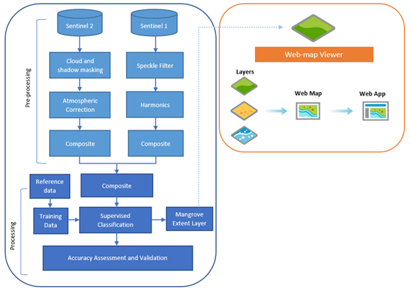
The Colombian Pacific coast mangrove extent was mapped primarily based on the workflow and semi-automated mangrove mapping methods applied by Shapiro et al. (2018). The analysis structure and methods were further supported and adapted according to approaches applied by Yancho et al. (2020) within the Google Earth Engine Mangrove Mapping Methodology. The mangrove cover extent was obtained by applying a pixel-based supervised classification approach and a Random Forest classifier. The composites derived from a combination of Sentinel-1 and Sentinel-2 images were used as input data for the models. Finally, the results are presented via a simple web map application for better access.
Data used: Sentinel-1, Sentinel-2, Mangrove Forests of the World (Giri et al, 2011), Global Mangrove Watch 2016 (Bunting et al. 2018), Global Mangrove Distribution, Aboveground Biomass, and Canopy Height (Simard et al., 2019), ALOS Global Digital Surface Model "ALOS World 3D - 30m (AW3D30)
Methods used: Google Earth Engine Mangrove Mapping Methodology (GEEMMW), Pixel-based supervised classification, Random Forest classifier, Web mapping, Generalization
Software used: Google Earth Engine, ArcGIS Pro, ArcGIS Online, Web AppBuilder
Analysis
Acces to the GEE repository containing the scripts used to classify the mangrove cover. A GEE account is required
Visualization
Access to the web map application presenting mangrove cover ditribution along the Colombian Pacific coastline.
Data download
Access to the output products from the classification, the thesis text, and poster