Within the agenda of “Spatial Modelling of Geographical phenomena in GIS”, the Department of Geoinformatics focuses on various issues concerning analyses and modelling of urban landscape in GIS (urban modelling). The most important topics include analyses and modelling of (a) rural and urban areas with the use of geocomputational methods (e.g. fuzzy sets and logic), (b) urban spatial structures, (c) spatial planning processes, and (d) development of the Urban Planner model. The most significant scientific outputs are:
URBAN & RURAL
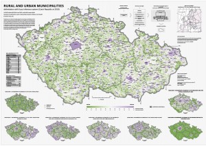
PÁSZTO, V., BRYCHTOVÁ, A., TUČEK, P., MAREK, L., BURIAN, J. (2015): Using a fuzzy inference system to delimit rural and urban municipalities in the Czech Republic in 2010. Journal of Maps, 11(2), s. 231-239.
PÁSZTO, V., TUČEK, P., MAREK, L., KUPROVÁ, L., BURIAN, J. (2010): Statistical inferences – visualization possibilities and fuzzy approach computing, In: Advances in Geoinformation Technologies 2010, VŠB – Technical University of Ostrava, ISBN 978-80-248-2357-7
URBAN PLANNER
BURIAN, J., ŠŤASTNÝ, S., BRUS, J., PECHANEC, V., VOŽENÍLEK, V. (2015): Urban Planner: model for optimal land use scenario modelling, Geografie, 120, No. 3, pp. 330–353.
BURIAN, J., BRUS, J., ŠŤASTNÝ, S. (2015): Urban Planner – model for land use suitability assessment, New Developments in Environmental Science and Geoscience, ISBN: 978-1-61804-283-5
BURIAN, J., ŠŤASTNÝ, S., ĆMIELOVÁ, B., RŮŽIČKA, O. (2015): Urban Planner – ArcGIS extension for land use modelling (poster), AGILE 2015, Lisabon, Španělsko
BURIAN, J., ŠŤASTNÝ, S., ĆMIELOVÁ, B., RŮŽIČKA, O. (2014): Urban Planner – tool for optimal landuse scenario modelling (poster), Esri User Conference 2014, San Diego, USA
BURIAN, J., ŠŤASTNÝ, S., MIKLOŠ, M. (2012): Urban Planner – tool for optimal landuse scenario modelling (poster), Applied Urban Modelling 2012, Cambridge
URBAN & SPATIAL PLANNING
BURIAN, J., BRYCHTOVÁ, A., VÁVRA, A., HLADIŠOVÁ, B. (2016): Analytical Material for Planning in Olomouc, Czech Republic. Journal of Maps, Vol.:12, Issue: 4, p. 649-654, DOI:10.1080/17445647.2015.1060177
BURIAN, J., BRYCHTOVÁ, A., VÁVRA, A. (2015): Proposal of urban plan symbology standardization: Olomouc region case study. 15th International Multidisciplinary Scientific GeoConference SGEM 2015, www.sgem.org, SGEM2015 Conference Proceedings, ISBN 978-619-7105-35-3 / ISSN 1314-2704, June 18-24, 2015, Book2 Vol. 2, 1051-1062 pp
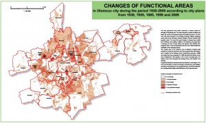
BURIAN, J., BRUS, J., VOŽENÍLEK, V. (2013): Development of Olomouc City in 1930 – 2009: Based on Analysis of Functional Areas. Journal of Maps, Vol.: 9, Issue: 1, p. 64-67, DOI:10.1080/17445647.2013.778800
PECHANEC, V., BURIAN, J., KILIANOVÁ, H., VOŽENÍLEK, V., SVOBODOVÁ, J. (2012): A participatory approach to spatial and environmental planning in different national perspectives. Rural Studies – Local and regional development – challenges and policy issues, vol. 27 Polish Academy of Science, 47-74s., ISSN: 1642-4689
URBAN ANALYSIS
POUR, T., BURIAN, J., MIŘIJOVSKÝ, J. (2016): Advanced extraction of spatial information from high resolution satellite data, XXIII ISPRS Congress, Commission III (Volume XLI-B3), 12–19 July 2016, Prague, Czech Republic, p. 905-907
POUR, T., BURIAN, J., MIŘIJOVSKÝ, J. (2016): Application of seath algorithm on high resolution data sets of selected cities, 16th International Multidisciplinary Scientific GeoConference SGEM 2016, www.sgem.org, SGEM2016 Conference Proceedings, Book 2, Vol I, pp. 585-592, doi:10.5593/sgem2016B23
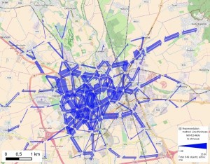
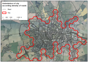
BURIAN, J., PÁSZTO, V., HAVLOVÁ, P. (2016): Delimiting the central areas of the cities by using GIS methods, 16th International Multidisciplinary Scientific GeoConference SGEM 2016, www.sgem.org, SGEM2016 Conference Proceedings, Book 2, Vol I, pp. 633-640, doi:10.5593/sgem2016B23
DOBEŠOVÁ Z., HÝBNER R. (2015): Optimal placement of the bike rental stations and their capacities in Olomouc, I. Ivan et al. (eds.), Geoinformatics for Intelligent Transportation, Lecture Notes in Geoinformation and Cartography, Springer International Publishing, Switzerland, 2015, 51-60s., ISBN 978-3-319-11462-0, DOI 10.1007/978-3-319-11463-7_4.
BURIAN, J., PÁSZTO, V., LANGROVÁ, B. (2014): Possibilities of the delimitation of city boundaries in GIS – Case study of medium-sized city, 14th SGEM GeoConference on Informatics, Geoinformatics and Remote Sensing, www.sgem.org, SGEM2014 Conference Proceedings, ISBN 978-619-7105-12-4 / ISSN 1314-2704, June 19-25, 2014, Vol. 3, 777-784 pp., DOI: 10.5593/SGEM2014/B23/S11.099
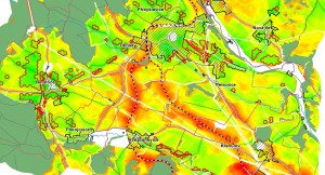
SINGH BOORI, M., VOŽENÍLEK, V., BURIAN, J. (2014): Land Cover Disturbance due to Tourism in Czech Republic. In Kömer, P., Abraham, A., Snášel, V.: Proceedings of the Fifth International Conference on Innovations in Bio-Inspired Computing and Applications IBICA 2014. Springer international Publishing. DOI 10.1007/978-3-319-08156-4_7, Advances in Intelligent Systems and Computing Volume 303, 2014, pp 63-72
DOBESOVA, Z., KŘIVKA, T. (2012): Walkability index in the urban planning: A case study in Olomouc city. J. Burian (ed.): Advances in Spatial Planning InTech, Rieka, Croatia, 2012, 179-196 s., ISBN 978-953-51-0377-6
DOBESOVA, Z. (2012): The Geocode Correction in the Database as a Base for Spatial Analysis, Advances in Computer Science, Proceedings of the 6th WSEAS European Computing Conference ECC 12 Prague, WSEAS Press, 511-516s. ISBN 978-1-61804-126-5
BURIAN, J., VOŽENÍLEK, V. (2012): Identification and analysis of urbanization and suburbanization in Olomouc region – possibilities of GIS analytical tools, In.: Advances in Spatial Planning (ed. Burian, J.), InTech,366 pp., ISBN 979-953-307-412-1.
PECHANEC, V., BURIAN, J., KILIANOVÁ, H., NĚMCOVÁ, Z. (2011): Geospatial analysis of the spatial conflicts of flood hazard in urban planning. Moravian Geographical Reports. Vol. 19, 1/2011.